
“It’s all downhill from here.”
It has an ominous ring to it, doesn’t it? I honestly could not remember the last time I spent so much hours walking DOWN. Hell on the knees and killer on the toes, if you ask me.
But I am getting ahead of myself.
(This is the third part of a multi-part post series on Trailblazing Tinglayan 2014, the Mt. Mosimos Climb. Check out Part 1 and 2 of the series here and here, respectively.)
Day 3. After one of the best night’s sleep outdoors we’ve ever had in a very long time, we all woke up a little before 4am for our assault to the summit of Mt. Mosimos. Cameras, trail foods, and flashlights in hand, we left the relative comfort of our campsite, where Manong Mario and Daniel will be left behind to “stand guard”. Sir Noel is leading the pack, since he’s the one who’s going to look for – and hack away – the trail.

Now, taking photos at dawn while hiking is not really advisable, since you have to keep your wits about you. Slipping is inevitable. Getting caught up in the brambles is almost expected. Getting cuts and nicks from various wild plants, and having your bonnet hooked clear out of your head by a wayward spiked vine, are also part of the experience. So, excuse me, if I couldn’t be bothered to take photos on the way up.
When it was a little lighter, though, and some of the morning light managed to penetrate the thick canopy of the mossy forest, we tried. Emphasis on “tried”.
Now if you’re expecting a summit that is like that of Mt. Pulag, you’ll most likely be disappointed once you reach the top of Mt. Mosimos. As for me, disappointed was the last thing I would describe myself as.

It was a dense area, with undergrowth so thick that you’ll practically be stepping on tree trunks most of the time. According to Manong Noel, this is not the only “summit” of this mountain. There is another one, but it’ll take another 3 to 4 hours to get there. We didn’t have that much time, so we stuck on this particular summit.


Nonetheless, while hanging around at the area, climbing the trees and basically camwhoring without end, we could feel our exhaustion from the climb slowly seep away. Some of us even climbed to the top of the tree (I couldn’t. You see, I require footholds on a tree that is essentially moss-covered, and after a few of us already climbed ahead, all the footholds are, well, gone.) to check out the view. According to them, what you’ll see is the mountain range marking the boundary between Kalinga and Abra (Do correct me if I’m wrong, it’s been known to happen.)


You know what they say about the ascent being only have the fun? In this case, it’s definitely true. While making the climb earlier, I was already mentally dreading what it would be like to go down later. The descent, for lack of a better word, was F-U-N.


Let’s see. Slippery trail. Mossy ground underfoot. Spiky foliage around you. Unstable footholds. Soft, muddy earth. Deceptive vines and tree barks. And then there was us.
‘Twas a disaster waiting to happen.
And oh what a laughtrip of a disaster it was!


Many times I have been fooled into clinging to a supposed tree, or lean against one for support, only for it to break right off, or crumble in my hands, leaving me flailing and trying to grab on to thin air. A couple of times I stepped on what I thought was a solid patch, only for it to give way underneath me and the next thing I knew, I am knee-deep into a hole.
And, as my friends would say, these slips add more flavor to the whole experience. Without them, the descent would have been utterly booooring. And we couldn’t have that, could we?

When we reached the campsite, breakfast preparation was already underway. Sir Mario was so thoughtful, making canes for all of us to use as support for the descent from Mt. Mosimos and from Balay.


Then it sank in. Going back to Tulgao West is going to be one killer of a descent.
Going up to Balay took us somewhere around 3-4 hours. Going down from Balay took a little more than an hour. (How is that fair?!)
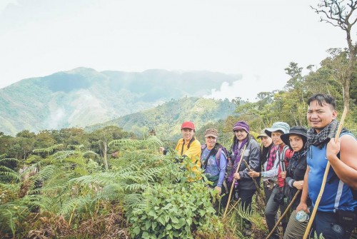
At the halfway point, we stopped and looked, and saw we still have a long way to go before we reach Balay. Can you spot the village in the photo below?


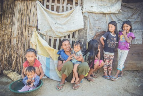
At Balay, we had a late lunch of pancakes and awesome coffee. We also mingled a bit.


Here are a couple of snaps of Balay, courtesy of Joseph Licdan.
We then proceeded with our descent back to Tuglao West barangay proper.


It rained when we were already at the bridge, but the downpour lasted no more than 15 minutes. We reached the home of Sir Joseph, repacked, left our dirty stuff, and took only what we needed for our overnight camp down at the falls.
When we set out for the 30-45 minute hike down to the falls, it was already dark. Once again, we relied on torches/flashlights.
Going down in the dark, on rice paddies and steep pathways, is no easy feat. I’d say it was quite a blessing, though, that we did it in the dark. Otherwise, the sight below us would have made us quake (even more) in our toes.
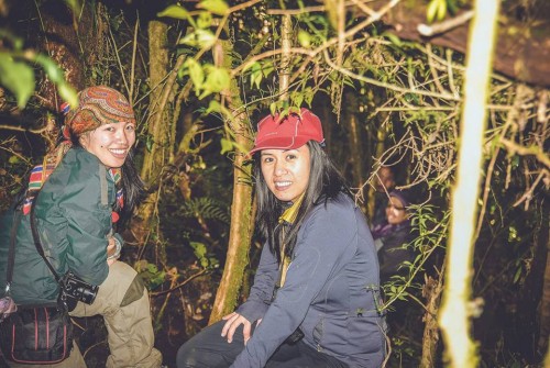
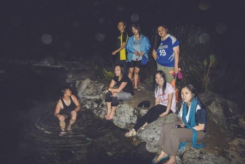
I think it took more than an hour to reach the campsite, which is right beside the river and waterfalls. We set up camp, then as the others prepped dinner, us girls proceeded to the Aatungan Hot Spring for a dip. “Aatungan” comes from the root word “atung”, which means “hot”. So, yeah, redundant much?
But oh what glorious heat! We could feel all the tensions and stiffness and soreness (and dirt!) getting washed away as we soaked in the veeeeeeery hot spring. With only the light of the moon overhead, we could have happily fallen asleep while in the water. We would have roasted come morning, though. There are simply risks that aren’t worth taking.
In the morning, we’ll get a glimpse of the Palangka Falls. And so will you. For now, I leave you this snap of us, post-hotspring soak.
Next post: The walk – and ride – home.